Photos
Enter a word or phrase to perform a general search across all records in the Photos catalog. You can also browse records in the catalog without performing a search.
Search Tips
- Searches are not case sensitive.
- Searching for multiple words connects them with OR by default. Matching records can contain any of the words.
- Connect multiple words with AND if you only want to see records containing both words.
- Use quotation marks to search for a phrase.
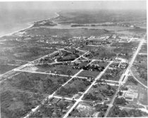
- Place an asterisk (*) at the end of a word as a wildcard.
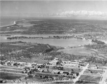
5500 results found. Records searched: 5500
-
-
0001 - Print, Photographic
Aerial view of Casey's Casey Pass near Venice Beach. Captain John Charles Casey assisted with the first U.S. Coast and Geodetic Survey of the Venice area from 1848 to 1851. The survey labeled present-day Venice Inlet as Casey’s Pass and the barrier island to the north was named Chaise’s Key. A map of Florida ordered five years later by Secretary of War Jefferson Davis had changed Chaise’s Key to Casey’s Key, in honor of the surveyor, who was also...
Record Type: Photo
-
0002 - Print, Photographic
Aerial view of Venice Inlet from the north showing Bay Point subdivision, Snake Island, and Inlet Circle with the houses moved from Edgewood subdivision in Venice.
Record Type: Photo
-
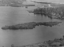
0003 - Print, Photographic
Aerial view of Roberts Bay looking southwest showing old sand road to Inlet Circle.
Record Type: Photo
-
-
-
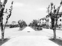
0006 - Print, Photographic
Venice Avenue looking east from median at Nassau Street showing origanal path, citrus trees, and Park View Hotel. circa 1927
Record Type: Photo
-
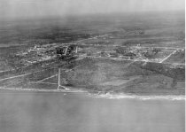
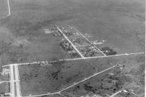
0007 - Print, Photographic
Aerial View of Venice looking north from Venice Army Air Base showing original air base entrance and rerouting of US 41
Record Type: Photo
-
0008 - Print, Photographic
Aerial view of Venice looking north from Ponce de Leon showing downtown area, Stone Grove, Nokomis, and Eagle Point with original Tamiami Trail thru Eagle point.
Record Type: Photo
-
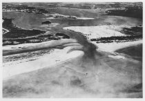
0009 - Print, Photographic
Aerial view of Venice looking east from Gulf of Mexico showing mouth of Deer Town Gully with outcrop (popular picnic area). See picture #11.
Record Type: Photo
-
001 - Print, Photographic
City of Venice Blanche Photo, Tampa, Fl. Venice Avenue Miami Avenue
Record Type: Photo

-
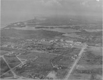
0010 - Print, Photographic
Aerial View of Venice looking north from Palermo Place showing downtown Venice and bays.
Record Type: Photo
-
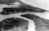
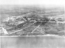
0011 - Print, Photographic
Aerial view of Venice looking east from the Gulf of Mexico showing the "Flamingo Ditch" with rocky outcrop (south of present Venice Villas); photo was taken in the late 1930s
Record Type: Photo
-
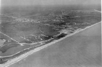
0012 - Print, Photographic
Aerial view of Venice looking southeast from just south of Venice jetties from airport.
Record Type: Photo
-
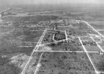
0013 - Print, Photographic
Aerial view of Venice looking north from south of San Marco showing Venezia Park, downtown Venice and Nokomis.
Record Type: Photo
-
0014 - Print, Photographic
Aerial view of Venice looking east from about where Vence Industrial section is now, showing Edgewood section of Venice and Venice farm road in upper left.
Record Type: Photo
-
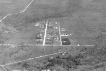
0015 - Print, Photographic
Aerial View of Venice looking southeast from about where Venice Industrial section is located.
Record Type: Photo
-
-
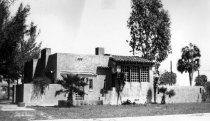
0016A - Print, Photographic
232 Milan Avenue, built 1926-1928. Original home of C. Franklyn Wheeler. Original print, copy negative
Record Type: Photo
-
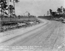
0017 - Print, Photographic
Hard shell road through Venice. First stretch of hard shell road running 13 miles through the 25000 acres of farm land east of Venice Koons # 61, same as 2008.21.079 #.39
Record Type: Photo